
About the NCR Trail
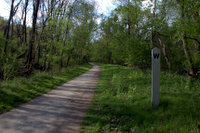
The Northern Central Railroad Trail, officially known as the Torrey C. Brown Trail, covers nearly 20 miles in Maryland, stretching from Ashland Road in Hunt Valley to the Mason-Dixon Line. The trail is 10 feet wide with a stone dust surface; it features clear and accurate mile markers along the whole length. The most popular activities on the trail are hiking, running, bicycle riding and horseback riding. The trail also provides access for fishing and tubing along the Gunpowder.
The NCR continues another 20 miles into Pennsylvania as the York County Heritage Trail, ending in the city of York, PA. The surface changes somewhat in Pennsylvania. The rails are still in place and the trail occasionally crosses from one side of the tracks to the other. The trail in PA features a cool tunnel and historic Hanover Junction.
Parking
Here are the major parking lots along the Maryland portion of trail, although there are many more small lots (including the Snails’ favorite Ashland Rd lot a Mile 0.0):
- Mile 0.5 Paper Mill: Take York Road (Route 45) to Cockeysville (Exit 18 off I-83). Turn right (east) on Ashland Road. Bear left onto Paper Mill Road. Go less than ½ mile, crossing the trail to the parking lot on the left. There are spot-a-pots at this location.
- Mile 2.0 Phoenix: Take York Road north of Shawan Road in Hunt Valley (Exit 20 off I-83). Turn right (east) on Phoenix Road. Travel 1.7 miles and look for the parking lot on the right.
- Mile 3.8 Sparks: Take York Road north of Shawan Road to Sparks (Exit 20 off I-83). Turn right (east) on Sparks Road. Go less than 1 mile to parking lot. This location features the Sparks Bank Nature Center, a water fountain, and a spot-a-pot.
- Mile 7.2 Monkton: Take I-83 to Exit 27, go toward Hereford (east) 0.4 miles on MD-137/Mt Carmel Rd. Turn right on York Road then immediately turn left (east) on Monkton Road. Follow for 3 miles, and look for the parking lot and park office on the left. This location features restrooms, water, telephones and picnic tables. The parking lot at this location is small, but there's plenty of space along the shoulder of Monkton Rd.
- Mile 10.8 White Hall: Take I-83 to Exit 27, go toward Hereford (east) 0.4 miles on MD-137/Mt Carmel Rd. Turn left on York Road and go 2.4 miles north. Turn right (east) on Weisburg Road for 1.4 miles. Turn right, staying on Weisburg Road for another 0.4 miles. The parking lot is on the right at Weisburg and White Hall Roads. Spot-a-pot.
- Mile 12.9 Parkton: Take York Road to Parkton (Exit 31 off I-83). Turn left (west) onto Frederick Road, and park at 18858 Frederick Road.
- Mile 15.5 Bentley Springs: Take York Road north of Parkton (Exit 33 off I-83). Turn left (northwest) onto Kaufman Road. Follow Kaufman Road for less than 1 mile, and turn left (west) onto Bentley Road and proceed to parking lot. Spot-a-pot.
- Mile 18.6 Freeland: Take York Road north almost to the Pennsylvania line (Exit 36 off I-83). Then turn left (west) onto Freeland Road. Follow for 2 miles to parking lot. Spot-a-pot.

